

The Char Dham Yatra in Uttarakhand is one of India’s most significant and physically demanding pilgrimage circuits. Covering Yamunotri, Gangotri, Kedarnath, and Badrinath, this Himalayan journey is not approached casually. For many families, planning a Char Dham Yatra takes years, physically, financially, and emotionally.
Unlike many temple visits in the plains, the Char Dham Yatra is shaped as much by geography as by faith. High-altitude roads, unpredictable weather, glacier-fed rivers, landslide-prone stretches, and narrow mountain valleys define the experience. The journey demands adjustment to distance, climate, altitude, and often to one’s own physical limits.
This is not only a temple visit. The Char Dham Yatra is a movement across river origins, ancient shrines, and some of the most demanding terrain in the Indian Himalaya.
What Is the Char Dham Yatra?
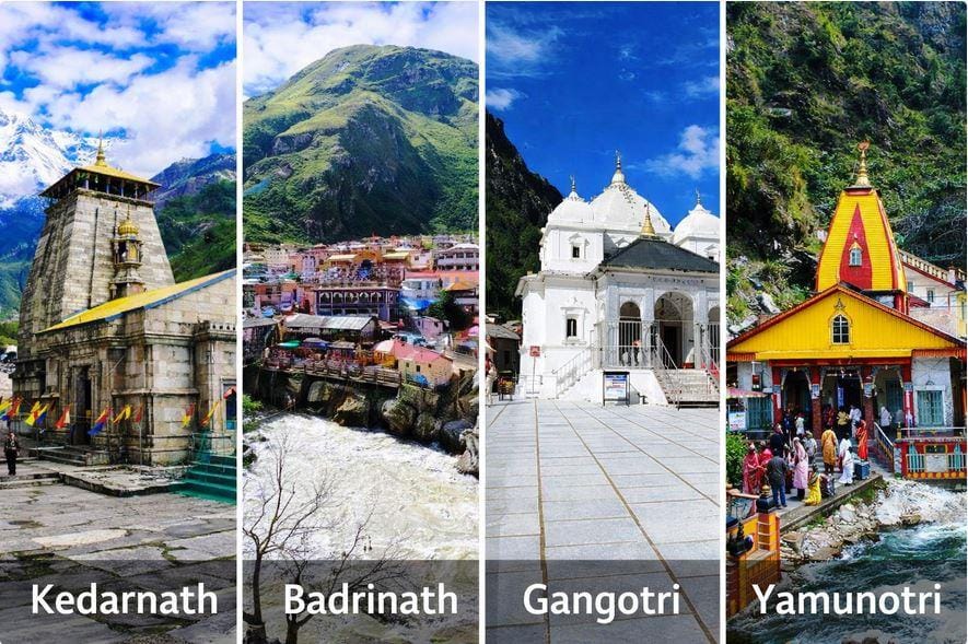
The Char Dham Yatra refers to a pilgrimage circuit in the Garhwal region of Uttarakhand, covering four sacred shrines:
- Yamunotri – dedicated to Goddess Yamuna
- Gangotri – dedicated to Goddess Ganga
- Kedarnath – dedicated to Lord Shiva
- Badrinath – dedicated to Lord Vishnu
Together, these four sites form what is known as the Himalayan Char Dham, distinct from the all-India Char Dham circuit.
Traditionally, the journey is undertaken once in a lifetime. For some, it is a vow. For others, it marks retirement, recovery, gratitude, or remembrance. The Char Dham Yatra carries personal meaning beyond its itinerary.
Char Dham Yatra Route: Traditional Order and Logic
The traditional route of the Char Dham Yatra follows a clockwise pattern across Garhwal:
Yamunotri → Gangotri → Kedarnath → Badrinath
This order reflects both geography and tradition.
The journey begins with Yamunotri and Gangotri, the sources of the Yamuna and Ganga rivers. From there, pilgrims move toward Kedarnath, associated with austerity and endurance, and finally to Badrinath, which represents balance and continuity.
Most yatras begin from Haridwar or Rishikesh. From there, roads gradually climb into the mountains. With every dham, altitude increases and terrain becomes more demanding. By the time pilgrims reach Kedarnath, the physical intensity of the Char Dham Yatra becomes clear.
Understanding this route helps travellers plan rest days, acclimatisation, and travel duration more realistically.
Char Dham Yatra Distance and Duration
The complete Char Dham Yatra circuit typically covers 1,500–1,700 kilometres, depending on route variations and starting point.
Most travellers complete the journey in 10 to 12 days, though elderly pilgrims or those travelling at a slower pace may extend it to two weeks.
Travel includes:
- Long mountain drives across winding roads
- A 16 km trek (one way) to Kedarnath (unless using a helicopter or pony)
- A 5–6 km trek to Yamunotri
- Moderate walking at Gangotri and Badrinath
Despite road improvements in recent years, this is not a comfortable sightseeing tour. The Himalaya still determines pace. Landslides, rainfall, road maintenance work, and peak-season traffic can affect schedules.
Planning buffer days is not optional; it is practical.
Overview of the Char Dhams
Yamunotri: The Beginning of the Circuit
Yamunotri is often the first stop in the Char Dham Yatra. The final stretch requires a trek from Janki Chatti through forested slopes and steep paths. The shrine is modest in scale but deeply rooted in ritual. (Read our detailed guide to Yamunotri Temple in Uttarakhand for trek distance, weather, and planning insights.)
Hot springs near the temple are used for cooking prasad, instantly blending landscape and worship. Yamunotri sets the physical tone of the journey; it introduces effort early.
Gangotri: Where the Ganga Begins
Gangotri stands beside the Bhagirathi River, which later becomes the Ganga in the plains. The town is quieter than other dhams and sits at a high altitude.
Here, the river is fast, cold, and narrow. Pilgrims often spend time by the water rather than inside the temple complex. The Char Dham Yatra begins to feel more environmental than ceremonial at this stage. (Explore our in-depth article on Gangotri Temple and the origin of the Ganga to understand its geography and spiritual significance.)
Kedarnath: Endurance and Elevation
Kedarnath is the most physically demanding part of the Char Dham Yatra. Located at over 3,500 metres, the temple requires either a long trek, pony ride, palki service, or helicopter access. (For route comparisons and travel options, read our guide on Kedarnath Temple travel planning.)
The weather changes quickly. Oxygen levels reduce noticeably at higher altitudes. Even those using helicopter services feel the impact of elevation.
After the 2013 floods, infrastructure has improved, but the setting remains stark and powerful. Kedarnath represents the peak intensity of the pilgrimage.
Badrinath: Structure and Continuity
Badrinath is comparatively accessible by road. The temple town has organised rituals, scheduled aartis, and developed facilities. (Our detailed guide to Badrinath Temple in Uttarakhand covers rituals, the best time to visit, and nearby places like Mana village.)
Situated along the Alaknanda River, Badrinath balances the rawness of Kedarnath with structured worship. Many pilgrims feel a sense of completion here, not because the journey was easy, but because it required effort.
Best Time for Char Dham Yatra
The Char Dham Yatra usually opens between late April and early May and continues until October or early November, depending on snowfall.
The most stable periods are:
- May to June (pre-monsoon): Clearer weather but higher crowds
- September to early October (post-monsoon): Fewer pilgrims, greener valleys, cooler temperatures
July and August bring monsoon risks, including landslides and road disruptions.
Early season travel can still be cold, especially at Kedarnath and Gangotri, where night temperatures drop sharply. Choosing the right travel window significantly affects both safety and the overall Char Dham Yatra experience.
Char Dham Yatra by Road vs Helicopter
In recent years, helicopter services have made parts of the Char Dham Yatra more accessible, especially for elderly pilgrims and those with limited time. However, the experience differs significantly depending on how the journey is undertaken.
By Road:
Most pilgrims complete the Char Dham Yatra by road, using private taxis, shared jeeps, buses, or organised tours.
Road travel offers:
- Gradual altitude gain, allowing better acclimatisation
- Flexibility to halt at towns like Uttarkashi, Guptkashi, or Joshimath
- Greater exposure to the Himalayan landscapes and local settlements
- Physical involvement through treks at Yamunotri and Kedarnath
It also requires patience. Traffic congestion, weather disruptions, and landslides can affect schedules, especially during peak season. For many, however, road travel allows the journey to unfold steadily rather than quickly.
By Helicopter:
Helicopter services operate seasonally and are most commonly used for Kedarnath.
- Kedarnath has regular shuttle services from helipads such as Phata, Guptkashi, and Sersi.
- Yamunotri has limited helicopter access near Kharsali, followed by a short ground transfer.
- Badrinath and Gangotri are primarily accessed by road, though premium multi-day helicopter packages covering all four dhams are available from Dehradun.
Helicopter travel reduces trekking strain and shortens the duration of the yatra. However:
- Flights are weather-dependent
- Weight restrictions apply
- Delays and rescheduling are common
- Altitude impact remains even during short visits
Helicopter services make access easier, but they do not eliminate the geographical realities of the Himalaya. The choice depends on health, time availability, and personal intention.
Pony and Palki Services at Kedarnath and Yamunotri
For pilgrims unable to complete the trek on foot, pony (horse/mule) and palki (palanquin) services are officially regulated and widely used at Kedarnath and Yamunotri. Seasonal rates are generally fixed by local authorities.
Kedarnath – Trek distance, approx. 16–18 km (one way)
- Pony (one way): approx. ₹2,500–₹3,500
- Palki (one way): approx. ₹5,000–₹7,000
Return fares are higher and vary by season and weight category. Services are arranged at the base points near Sonprayag and Gaurikund.
Yamunotri – Trek distance: approx. 5–6 km (one way)
- Pony (one way): approx. ₹1,000–₹1,800
- Palki (one way): approx. ₹2,500–₹3,500
Since the Yamunotri trek is shorter but steep, palkis are commonly used by elderly pilgrims. Rates may change slightly each season and are usually displayed at official counters during the yatra period.
Using pony or palki services is practical and common. However, early departures are advisable, and weather conditions can affect movement speed.
Whether undertaken by road, helicopter, pony, or on foot, the Char Dham Yatra remains shaped by altitude, terrain, and weather. Convenience can reduce physical strain, but it does not replace preparation.
Who Should Plan Carefully
The Char Dham Yatra reaches altitudes above 3,500 metres. Oxygen levels reduce noticeably at higher altitudes, especially at Kedarnath and Badrinath.
Elderly travellers, individuals with heart or respiratory conditions, and those not used to high altitudes should:
- Consult a doctor before planning
- Avoid rushing the itinerary
- Stay hydrated
- Allow acclimatisation time
- Avoid sudden physical exertion
This journey rewards preparation more than enthusiasm.
Registration and Preparation
Biometric registration for the Char Dham Yatra is mandatory and can be completed online or at designated centres in Uttarakhand.
Pilgrims should also prepare:
- Valid ID proof
- Warm clothing even in summer
- Basic medicines
- Rain protection
- Comfortable walking shoes
- Cash for remote stretches
Mobile connectivity becomes limited in upper stretches, especially near Kedarnath and Yamunotri. Practical preparation reduces stress and allows the journey itself to remain central.
Common Mistakes First-Time Pilgrims Make
- Underestimating altitude impact
- Overpacking unnecessary items
- Ignoring weather forecasts
- Not keeping buffer days
- Treating the Char Dham Yatra like a fixed-schedule tour
Flexibility is not optional in the Himalaya. It is essential.
The Cultural Weight of Completion
For many families, completing the Char Dham Yatra is spoken about for years afterwards. It becomes part of family memory, mentioned in conversations, remembered during festivals, or referenced in times of difficulty. The journey often matters not only to the individual who travels, but to the household that planned it together.
Why the Char Dham Yatra Endures
Despite modern roads, digital registration, and helicopter services, the Char Dham Yatra has not become casual tourism. The terrain still demands effort. The distances remain long. The weather still interrupts plans.
The Char Dham Yatra is not defined only by temples, but by movement, across rivers, valleys, altitude shifts, and personal thresholds. It remains one of the few journeys in India where geography still visibly shapes belief.
If you are exploring Himalayan pilgrimages more deeply, read our complete guide to the Char Dham temples of Uttarakhand, where each shrine is explained individually.
Frequently Asked Questions About Char Dham Yatra
Q1. What is the Char Dham Yatra?
The Char Dham Yatra is a pilgrimage circuit in Uttarakhand covering Yamunotri, Gangotri, Kedarnath, and Badrinath.
Q2. What is the traditional route of the Char Dham Yatra?
The traditional order is Yamunotri → Gangotri → Kedarnath → Badrinath.
Q3. How many days are required for the Char Dham Yatra?
Most travellers complete the Char Dham Yatra in 10–12 days.
Q4. What is the total distance of Char Dham Yatra?
The full circuit usually covers around 1,500–1,700 km, depending on the starting point.
Q5. When is the best time for the Char Dham Yatra?
May–June and September–early October are generally considered the most stable periods.
Q6. Is registration mandatory for the Char Dham Yatra in 2026?
Yes. Biometric registration is mandatory for all pilgrims undertaking the Char Dham Yatra. It can be completed online through the official Uttarakhand government portal or at designated registration centres across the state. Pilgrims are required to carry valid identification and complete the process before proceeding to the dhams.

